Showing posts with label weather. Show all posts

Sunday, March 15, 2026

Montgomery County under severe storm threat Monday


The latest forecast from the National Weather Service Storm Prediction Center portends trouble for the Washington, D.C. suburbs and central Maryland tomorrow, Monday, March 16, 2026. Many meteorologists are saying the NWS prediction is showing the highest chance of a tornado or derecho event they've seen in many years. The NWS predicts there is a 15-29% chance of a tornado in Montgomery and Frederick Counties Monday. The "moderate" designation means "widespread severe storms are likely," with severe weather most likely between 3:00 PM and 9:00 PM.


Such a forecast underscores the importance of monitoring weather forecasts and NWS bulletins over the next 36 hours. Make sure to bring indoors or secure any objects in your yard or on your balcony that could be lifted by high winds. Replace batteries in flashlights and transistor radios as needed tonight, try to fully charge your cellphone, and ensure you have at least half a tank of gas. A few days' supply of non-refrigerated snacks and water bottles can't hurt. Finally, have a plan for all occupants of your home to quickly move to the basement or lowest level of your house if you receive a Tornado Warning on your phone.


Thursday, January 22, 2026

Panic grocery buying begins ahead of snow in Montgomery County (Photos)


Several days of media coverage of the snow storm expected to arrive Saturday night in the Washington, D.C. area has inspired a run on essential items at local grocery stores. Empty shelves were visible in some aisles at Harris Teeter in downtown Bethesda last night. Products being snapped up include the old stalwarts of milk, toilet paper, and paper towels. 


Shoppers are dutifully following new health advice from Robert F. Kennedy, Jr., and are buying whole milk over the low-fat options. Of course, if power goes out due to ice or falling trees, massive supplies of milk will be of little value. Also going fast under RFK, Jr.'s guidelines: red meat. 


Snow totals were expected to top 13" in initial guesses, but the National Weather Service Winter Storm Watch is now talking about 5-10" of snow accumulation. Given the decline of area government resilience in the face of even a few inches of snow this century, 5-10" could paralyze the region for days. Back in the 90s, Metrobus and Ride On kept going on major routes under reduced frequency, and Metro certainly ran on underground segments if not aboveground with more intense snow plowing operations. In recent years, the entire transit system shuts down during moderate to heavy snowstorms, and governments urge residents to "shelter in place." Heckuva job, Brownie!


Incompetence of government means you're on your own until plows and utility crews belatedly reach your neighborhood. Make sure you have plenty of batteries for flashlights and a transistor radio to receive news and weather updates in the event of a power outage. Warm clothes and blankets are essential, as well. Shelf-stable milk will be a lot more useful than those perishable plastic jugs people are hoarding. And fill your gas tank at least halfway.


Tuesday, January 14, 2025

Germantown firm launches state-of-the-art weather station product


AEM
, a Germantown firm specializing in weather and environmental monitoring products, has launched a new, state-of-the-art weather station, it announced Monday. The Apex Automated Weather Station meets the strict standards of the World Meteorological Organization (WMO), AEM said. It monitors wind, rain, solar activity, temperature, humidity, and atmospheric pressure. The station has sophisticated data communication features to transmit and share data worldwide. AEM anticipates a wide public and private customer base, across fields such as weather forecasting, aviation, and wildfire and environmental monitoring.

Wednesday, August 7, 2024

When will Tropical Storm Debby impact upper Montgomery County?


Tropical Storm Debby is currently 471 miles from Montgomery County, Maryland, which will feel the former hurricane's impacts over the next three days. The storm will affect the entire Washington, D.C. metro area from around 8:00 PM Thursday night to 1:00 AM on Saturday morning. Accuweather is currently forecasting a total rainfall of 4 to 8 inches, with peak wind gusts of 40 MPH. The peak of the storm is expected to be from 8:00 AM to 8:00 PM on Friday, when the most rain will fall on the area.

Maryland Gov. Wes Moore

Maryland Gov. Wes Moore has declared a State of Preparedness ahead of the storm. "The safety of Marylanders is our top priority," Moore said in a statement. "By declaring a State of Preparedness, I am directing the Department of Emergency Management to coordinate the comprehensive preparation of State government ahead of potential impacts from the remnants of Tropical Storm Debby. Residents and visitors should monitor local weather forecasts, remain vigilant, and be prepared to follow safety instructions from local emergency officials."

Remember to keep phones and devices charged ahead of the storm. Now is the time to check batteries in your flashlights, and purchase additional batteries. Have a small transistor radio to monitor emergency bulletins and weather conditions if you lose power. And make sure your gas tank is at least half-full.

Tropical Storm Debby is currently approaching the coast of South Carolina. Its maximum sustained wind speed is 60 MPH, according to the National Weather Service, and it is moving northeast at 5 MPH. The storm is blamed for the deaths of six people in the southern United States so far.

Images courtesy NOAA, Office of Gov. Wes Moore

Saturday, September 23, 2023

Tropical Storm Ophelia makes landfall, already impacting Maryland/Washington, D.C. area


Tropical Storm Ophelia has made landfall near Emerald Isle, North Carolina, but the outer rain bands of the storm had already entered the Washington, D.C. area overnight. What will the impacts of Ophelia on the upper Montgomery County area be? The National Weather Service predicts rainfall amounts from 2-4" in the Montgomery County/Washington, D.C. area. High winds with gusts up to 45-55 MPH are also anticipated.

Montgomery County and Washington D.C. are under a National Weather Service-issued Wind Advisory from 8:00 AM to 8:00 PM today. The NWS forecasts northeast winds of 20 to 30 MPH, with gusts up to 55 MPH expected. Gusts up to 50 mph are possible along the immediate shore of the Chesapeake Bay and Tidal Potomac. Ocean City, Maryland is experiencing street flooding and wind gusts up to 50 MPH.Secure any outdoor furniture or objects light enough to blow away, or bring them indoors.

Maryland Governor Wes Moore has
declared a State of Emergency

Maryland Gov. Wes Moore has declared a State of Emergency. "If you can avoid driving or being out during the storm, please do so," Moore said. "We are expecting an extended period of strong winds, heavy rainfall, and elevated tides." Flooding, falling limbs, downed trees and power outages are expected.

Ophelia is currently located 25 miles WNW of Cape Lookout, North Carolina. Its sustained winds measured at Cape Lookout are currently 61 MPH, with gusts up to 73 MPH. The storm is moving NNW at 9 MPH, and will affect the D.C. region through Sunday.

Heavy rainfall and sustained wind gusts will combine for conditions that favor trees falling, causing damage and power outages. Charge cellphones and make sure you have batteries for flashlights and radios.

WMATA reports Metrobus routes D33 Westbound and E4 Westbound are temporarily detouring at Military Road and 14th Street NW, and resuming their routes at Military Road and 16th Street NW, due to weather conditions. Pepco is reporting a few, small power outages in Gaithersburg at this hour.

Tracking map courtesy National Hurricane Center

Monday, September 4, 2023

Gaithersburg Labor Day Parade canceled for 2023


The Gaithersburg Labor Day Parade scheduled to take place this afternoon, September 4, 2023, has been canceled. Mayor Jud Ashman announced the cancellation Sunday. He said the reason for the cancellation was the high temperatures forecast for today. Accuweather predicted a high of 98 degrees for the day. The parade will not be rescheduled.

Sunday, July 30, 2023

Germantown, Montgomery Village, Goshen, Laytonsville among hardest hit by power outages after storm

Pepco crews staging at the 7-Eleven store
on River Road in Bethesda this morning

Over 10,000 Pepco customers remain without power this morning in Montgomery County, but that number is down about 60,000 from the height of last evening's thunderstorm damage. The weather event, and resulting tree and power line damage, has been one of the few significant tests for Pepco since the electric utility was acquired by Exelon in 2016. Yesterday's storm appeared deceptively routine for late summer, but spawned straight line winds in areas like North Bethesda and Rockville, and had some in Northwest Washington, D.C. reporting a tornado in their community.

Southwest Bethesda neighborhoods like Springfield, Sumner, Wood Acres, Bannockburn and Spring Hill are still experiencing significant power outages. Grid resiliency issues reared their head again in the Westbard area long after skies had cleared Saturday night. Residents there who were fortunate enough to retain power after the storm last night report experiencing brownouts at 2:12 AM and 4:32 AM. The 4:32 AM brownout was an extended one, as after a split-second blackout that ravaged appliance motors, light fixtures were shimmering and flickering until all power was lost around 4:45 AM. Power was then restored around 4:48 AM. Interestingly, both brownout episodes reported seem to coincide with brand new power outages in the Westbard and Wood Acres/Searl Terrace areas, which the Pepco outage map indicates were reported at 2:15 AM (Searl Terrace) and 4:53 AM (Westbard Avenue). This morning's brownouts follow three sunny day brownouts in the Westbard area two weeks ago.

In North Bethesda, apartment building residents reported being in the dark Saturday night, and outages persist around Grosvenor, Garrett Park, Tilden Lane, Randolph Hills and the Randolph Road corridor this morning. Things aren't looking much better in the Twinbrook and Rollins Park areas of Rockville.

Aspen Hill is still smarting today with many outages. Fortunately for those without air conditioning, today's high will "only" be 85 degrees, instead of the 99 degree peak experienced last Friday. Outages also persist around Leisure World, Bel Pre Road, Wheaton, Kensington, Kemp Mill, Takoma Park, Hillandale, Colesville and Fairland. 

The storm appears to have cut a straight path across Montgomery Village, Goshen, and Laytonsville, judging from the large number of outages there. Outages remain in the Kentlands, Montgomery College-Germantown campus, Olney and Sandy Spring areas. 

Thursday, June 29, 2023

Gaithersburg cancels several events due to poor air quality


The Washington, D.C. area, including Montgomery County, is under a Code Red air quality alert due to smoke drifting south from Canadian wildfires. As a result, the City of Gaithersburg has canceled several outdoor events that were scheduled for today or tonight, Thursday, June 29, 2023. Canceled are the Casey Farmers Market, and the Evenings in Olde Towne Concert. 

Sunday, April 9, 2023

Montgomery County issues hypothermia alert


The Montgomery County Office of Emergency Management and Homeland Security has issued a Hypothermia Alert for Monday, April 10, 2023, between the hours of 2:00 AM and 10:00 AM. During that time, the wind chill is forecast to be below 32 degrees. 

A Hypothermia Alert means that conditions present a danger of hypothermia or frostbite to those outdoors for extended periods. Dress warmly and wear layers if you must spend significant time outdoors during the hours covered by the alert. If you have safety concerns about people or pets, you are asked to call 301-279-8000.

Thursday, April 6, 2023

Montgomery County under Severe Thunderstorm Watch until 10 PM


The National Weather Service has issued a Severe Thunderstorm Watch for central and southern Maryland, Northern Virginia, and Washington, D.C., effective until 10:00 PM tonight, April 6, 2023. Violent thunderstorms are expected. Isolated wind gusts up to 70 MPH and large hail are possible. It is currently 85 degrees, but temperatures tonight will plunge into the 40s after the storms pass through the area.

Make sure your phone is charged, and that you have fresh batteries in your flashlight. Keep a battery-powered radio nearby, and retrieve any objects that might be blown around by winds from your yard or balcony.

Thursday, September 29, 2022

Hurricane Ian remnants to impact Montgomery County sooner than expected


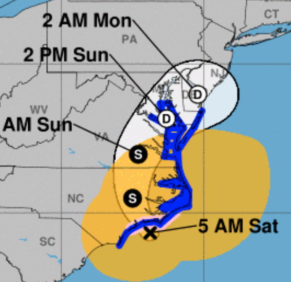
The worst of Hurricane Ian may have already passed in Florida, but the now-Tropical Storm is expected to make a speedy trip up the East Coast, including a jaunt out to sea and another landfall somewhere in the South. Yesterday, Ian's timetable for arrival in the Washington, D.C., Maryland and North Virginia area began to look like it was slipping from early next week to this weekend. Now, Accuweather is forecasting the first rains of Ian to arrive in the Mid-Atlantic as early as tomorrow. 

Tropical rain showers are now expected all weekend, and showers may continue from Monday into Wednesday. This does not look good for events like Taste of Bethesda this Saturday. Rain associated with Ian will arrive well ahead of the actual storm center, which is expected to pass through Maryland sometime Sunday night or early Monday morning.

Ian has further business south of here first, however. After crawling across mainland Florida, the storm will go back over the Atlantic, and make another landfall tomorrow evening. Accuweather currently predicts Ian's landfall will be somewhere near the border of Georgia and South Carolina Friday night; the National Hurricane Center's prediction is for a landfall in South Carolina. 

The full impact of Ian's second landfall, and the strength of the storm's remnants when it arrives here in the D.C. area, will be determined by how long it drifts over the waters of the Atlantic prior to Friday night's landfall. The National Hurricane Center says the storm could again near hurricane strength as it approaches land.

Ian already has shown plenty of destructive power after making landfall as a Category 4 hurricane. Over 2 million utility customers in Florida are currently without electricity. Accuweather reports that every customer in Hardee County, Florida is in the dark. Part of the Sanibel Causeway collapsed, the only bridge between Sanibel Island and mainland Florida. 

Florida Gov. Ron DeSantis said earlier this morning that helicopter rescues are being performed on barrier islands by the Coast Guard and Florida National Guard. He said 100 portable cell towers are being set up to restore some level of phone service, and that power line infrastructure in the hardest hit areas would in some cases have to be entirely rebuilt. Pine Island Bridge, like the Sanibel Causeway, is damaged and impassable, he added.

Fox Weather reports that there are believed to be hundreds of fatalities in Lee County, Florida, according to the sheriff there. Accuweather reports one confirmed death in Florida from Hurricane Ian, a 72-year-old man in Deltona. He slipped down a hill behind his home into a flooding drainage ditch while trying to drain his pool as the storm approached his area at 1:00 AM this morning. Fox Weather also reports Ian has caused a 200-year flood event in Orlando. More than a foot of rain has fallen on the city.

DeSantis said his state has all of the supplies it needs for storm victims. "It's much better to donate financially, rather than sending items. We've got a lot of items," he said at a news conference this morning. Those seeking to help storm victims displaced in Florida can have the greatest impact by donating funds at FloridaDisasterFund.org, or text DISASTER to 20222, he said. Florida First Lady Casey DeSantis said the fund has already raised $1.6 million in the last 24 hours.

Tropical Storm Ian's current location is 40 miles east of Orlando, the National Hurricane Center reports. Its current maximum sustained winds are at 65 MPH, and it is moving NE at 8 MPH.

Graphic courtesy Accuweather.com

Tuesday, September 6, 2022

Flood watch in effect until 2:00 PM today for Central Maryland, Washington, D.C., Northern Virginia


The National Weather Service has issued a Flood Watch for all of the Washington, D.C. metropolitan area, including Montgomery County and Central Maryland to the border with Pennsylvania. It is in effect from 4:00 AM to 2:00 PM this afternoon, September 6, 2022. There is the possibility of rainfall of 2-3" during this time, with potential totals up to 5" in some areas, due to heavy showers and possible thunderstorms.


Expect creeks, streams, rivers and flood-prone areas to experience high water levels and overflows. If you see high water in the road ahead, do not attempt to drive through it. Turn around and find an alternate route.

Wednesday, August 10, 2022

Flood watch in effect for Montgomery County as severe storms approach


Severe thunderstorms are expected to pass through the area this afternoon and evening. The National Weather Service has issued a Flood Watch that will remain in effect until 11:00 PM tonight for Montgomery County, Prince George's County and most of Maryland west of the Chesapeake Bay, Washington, D.C. and Northern Virginia. Rainfall amounts of 2-4" are expected, in timeframes as little as one or two hours, leading to potential flash flooding. Isolated strong wind gusts are also expected.


Maryland Gov. Larry Hogan (R) issued a statement this afternoon regarding the severe weather forecast. "More severe weather is expected to impact our state this afternoon and evening, including thunderstorms that could produce damaging wind gusts, heavy rainfall, and flash flooding," Hogan said. He urged residents to "please monitor local forecasts, exercise caution while traveling, and never drive through standing water."

Now is the time to charge your devices, and check the batteries in your flashlights. Bring objects that might fly away in from yards and balconies. Have a battery-powered radio to receive information in case of power outages. For Pepco customers, download the Pepco app to report power outages.

Monday, July 18, 2022

Severe Thunderstorm Watch issued for Montgomery County


The National Weather Service has issued a Severe Thunderstorm Watch for a large area of the Mid-Atlantic and Northeastern United States, stretching from Lynchburg, Virginia to lower New York and Western Connecticut. All of the Washington, D.C. region, including Montgomery County and Prince George's County, are under the watch until 10:00 PM tonight. This follows a Flood Watch for much of that area that is in effect until midnight tonight.

Between now and 10:00 PM, severe thunderstorms are possible. These storms may spawn tornadoes, isolated ping-pong-size hail, and scattered wind gusts up to 70 MPH. The first storms appear to be impacting northern Montgomery County - including Potomac, Germantown and Damascus, and parts of Northern Virginia and Frederick County, including Mount Airy and Urbana. Specifc severe thunderstorm warnings have been issued for those areas.

Be prepared by ensuring flashlights and radios have fresh batteries, and that your phone is fully-charged. Bring any objects that could become airborne inside from yards and balconies. Move to a lower level or interior room if a thunderstorm warning is issued for your area.

Map courtesy National Weather Service

Flood watch issued for Montgomery County


The National Weather Service has issued a Flood Watch for large portions of the Washington, D.C. and Baltimore metropolitan areas. A possibility of severe thunderstorms during the late afternoon and early evening hours tonight, along with potential rainfall rates of 1-2" per hour, may cause flash flooding between 4:00 PM and midnight. Jurisdictions under the flood watch include Montgomery County, Prince George's County, Washington, D.C., Arlington County, Alexandria, Fairfax County, Loudoun County, Prince William County, Bowie, Anne Arundel County, Howard County, Carroll County, Baltimore City, Baltimore County and Harford County.

Friday, May 27, 2022

Tornado watch issued for Montgomery County, Washington, D.C., parts of Maryland and Virginia until 2 PM


Montgomery County is under a tornado watch until 2:00 PM today, May 27, 2022. The National Weather Service has issued the tornado watch for Washington, D.C., and large portions of Maryland and Virginia. A tornado watch means that weather conditions may generate one or more tornadoes in our area. Isolated hail up to a quarter in size is possible. Winds may gust up to 70 MPH.

Violent thunderstorms are possible this afternoon and evening. The area is under a flood watch until 11:00 PM tonight. High temperature today will be 74 degrees. Accuweather is predicting thunderstorms are likely between 3:00 and 6:00 PM today, and around 9:00 PM tonight.

If a tornado is reported in your area, move quickly into a basement level or interior room. Take a flashlight and listen to local weather information on a cellphone or battery-powered radio. In advance of storms, take the opportunity to charge your cellphone. Remove any items that might blow away from your yard or balcony.

Friday, March 11, 2022

Winter weather advisory issued for Montgomery County Saturday


The National Weather Service has issued a winter weather advisory that includes Montgomery County for tomorrow, Saturday, March 12, 2022, from 6:00 AM to 3:00 PM. Accuweather and the NWS are forecasting a potential accumulation of 1-to-2 inches of snow. 

While snow is not expected to accumulate by any significant degree on roads and sidewalks, due to warmer temperatures, they will still be slippery from mixed precipitation. Winds may gust up to 50 MPH, causing trees and limbs to fall, and power outages. 

Rain is expected to begin after midnight tonight, and turn to snow around 10:00-11:00 AM Saturday. The temperature will steadily drop throughout the day on Saturday, reaching a brutal low of 19 degrees at 6:00 AM Sunday, with potential for icy spots on wet surfaces. 

Image courtesy National Weather Service

Monday, January 17, 2022

Snow gives way to sleet, rain and wind in Montgomery County


A Sunday snowstorm turned out to be a minor one, in general, for Montgomery County. Snow coated the area for several hours starting Sunday afternoon, but eventually transitioned to sleet, freezing rain, and then rain, as temperatures rose. The main concerns today will be blustery winds and wet or slushy road and sidewalk conditions. There is a wind advisory in place today, warning of occasional gusts reaching 40-55 MPH.


The National Weather Service advises that any loose objects in yards and on balconies be brought indoors. Drivers and pedestrians should be prepared for falling trees and power lines, and power outages. There is currently a small power outage in North Bethesda, affecting 5 Pepco customers near Fernwood Road and Democracy Boulevard. Pepco estimates power will be restored there at 6:00 AM this morning. There are also small outages in the Homewood area of Kensington, and in Forest Glen directly adjacent to the Capital Beltway.


Metrobus is on a Saturday Supplemental schedule today. Ride On bus is on a holiday schedule, and Ride On extRa and Flex services are not operating. The current temperature is one degree above freezing, and will rise steadily to a high of 36 degrees in the early afternoon hours. Expect occasional snow flurries or light rain this morning, giving way to cloudy and dry conditions by noon. The NWS forecasts that any notable snowfall today will be limited to the mountains to our west.


Wednesday, August 4, 2021

Maryland earthquake felt in Montgomery County, across DC region


UPDATE - 3:00 AM, August 4, 2021: The USGS now reports that the earthquake occurred at a depth of 3.4 kilometers. Latest USGS map pinpoints Clarksville, MD as epicenter, although it has not been officially named as such yet.

A 2.1 magnitude earthquake was felt in Bethesda, Rockville, Silver Spring, Derwood, and other parts of Montgomery County; Prince George's County, and Howard County at 2:11 AM this morning. The sound was audible here in Montgomery County, and was more noticeable than the shaking of the ground. According to the United States Geological Survey, the epicenter of the earthquake was 3 km from Highland, Maryland.

Friday, February 7, 2020

Gaithersburg, Germantown, Clarksburg, Damascus hit by unusual January storm

Damaged car on
Norbeck Road
The upcounty area of Montgomery County is being pounded by severe storms this morning. A tornado was issued for parts of Gaithersburg and Germantown, as well as the northeast corner of the upcounty near the Howard and Carroll County borders. Flooding has been reported across the upcounty, as have fallen trees and power lines. The whole county is being hit by the unusual February summer-style storm, but the upcounty is being affected the most.
Power lines, tree down on
Darnestown Road at
White Ground Road
Montgomery County Fire and Rescue Services have received so many emergency calls that they are now operating under Condition Red, which means there may be longer response times, particularly for non-critical incidents. Violent weather and storm damage have also impacted parts of Poolesville, Rockville and Silver Spring, most notably in the Dawsonville, Norbeck Road and Layhill Road areas.

Route 109 is currently blocked between MD 355 and the I-270 overpass after a tree fell across the roadway. Some lanes are also blocked at Route 28 and Route 107. Trees are also reported down by MCFRS on Circle Gate Drive in Germantown.

Photos by Pete Piringer/MCFRS